Street maps and links to official transport maps
In London TfL (Transport for London) coordinate all public transport. One of the aspects of this duty is releasing the official tourist and public transport maps.
While you’re in London, you can grab physical copies of the maps at different information centres. The most sought-after is undoubtedly the London Underground map, which is available at most underground stations in dispensers located in public areas. Best of all, these maps are free!
The TfL home page for public transport maps features links to maps for various modes of transport, including buses, trains, the underground, trams, and river services. Additionally, there are specific maps that highlight which underground stations are equipped with lifts or offer stair-free connections.
In today’s digital era, the availability of paper-based public transport maps is steadily declining. Many of the options now consist of individual route or district maps, rather than the comprehensive maps that were once prevalent just a few years back.
London Public Transport fare zones
London organizes the public transportation network into zones that extend outward from the city centre. Zone 1 features most hotels and popular attractions.
Heathrow Airport is situated in Zone 6, while they designate Zone 9 as the outermost zone.
For most travellers, the journey will typically be confined to the two central zones, 1 and 2. The London Underground map, clearly indicates the stations along with their respective zones.
Certain stations, such as Turnham Green, span two zones, allowing you to choose the zone that offers the best fare calculation for your trip.
Finding which zones your journey passes through is a major reason for consulting a map, even if you live in London.
A new addition arrived in summer 2022: the Elizabeth Line. This is the long awaited line linking East and West London, part of the Crossrail Project.
Visit our Elizabeth Line – London’s east-west railway by TfL page for more information.
Tourist and public transport maps London Underground, DLR & rail service
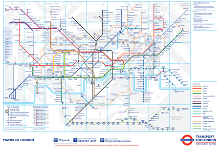
Underground
The London Underground Map is fairly simple to use. It shows colour coded Underground lines, and, importantly, which railway stations are in which travel zones. (This will affect the ticket price.)
Night Tube
A separate Night Tube map is available for use on Friday and Saturday nights, on selected lines.
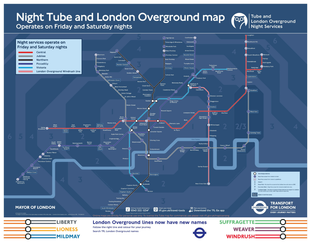
Overground
London also has a large commuter railway network, south of the river, the railway is dominant not the Underground. The Tube and Rail map integrates the two networks onto one map and also includes the Docklands Light Railway (DLR) which though not strictly correct can be thought of as part of the London Underground.
Useful versions of the Tube map
- Maps available in 15 languages
- A large print tube map
- A map showing tube stations which have either lift, escalators or ramps for accessibility
- A map showing which lines a bicycle can be taken on
- A walking map shows you walking times between stations – sometimes it can be quicker to walk!
Visit our London Underground page for more information.
Docklands Light Railway (DLR)
A fast, affordable, and flexible light railway to help people travel around the London Docklands area.
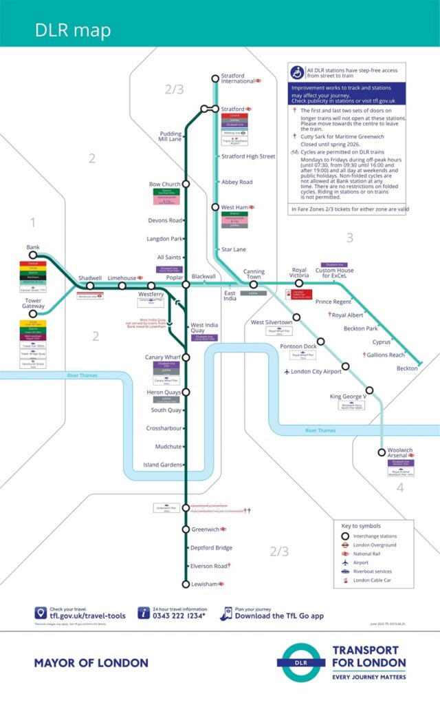
Visit our Docklands Light Railway (DLR) page for more information.
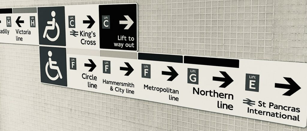
Accessibility and facilities maps
Accessibility and step-free access maps
Transport for London creates maps of the London Underground system in various formats, such as large print and audio. You can discover information about step-free London Tube stations and accessibility features for the London Underground, London Overground, and TfL Rail.
London Underground toilet map
A useful map showing which stations have toilets, baby-changing stations and accessible facilities.
London bus maps
Paper bus maps
It appears that paper bus maps are becoming a thing of the past. Once, you could easily grab one from an Underground ticket office, but that’s no longer an option.
TfL offer two types of online bus maps – the simplified tourist bus map and the ‘spider’ bus maps, covering individual boroughs.
Spider borough bus maps
When considering using a bus map in London you need to bear in mind that TfL now present the bus maps as individual spider bus maps for different boroughs in London. Therefore in order to use them effectively, you need to know the name of the borough your hotel or attraction is in.
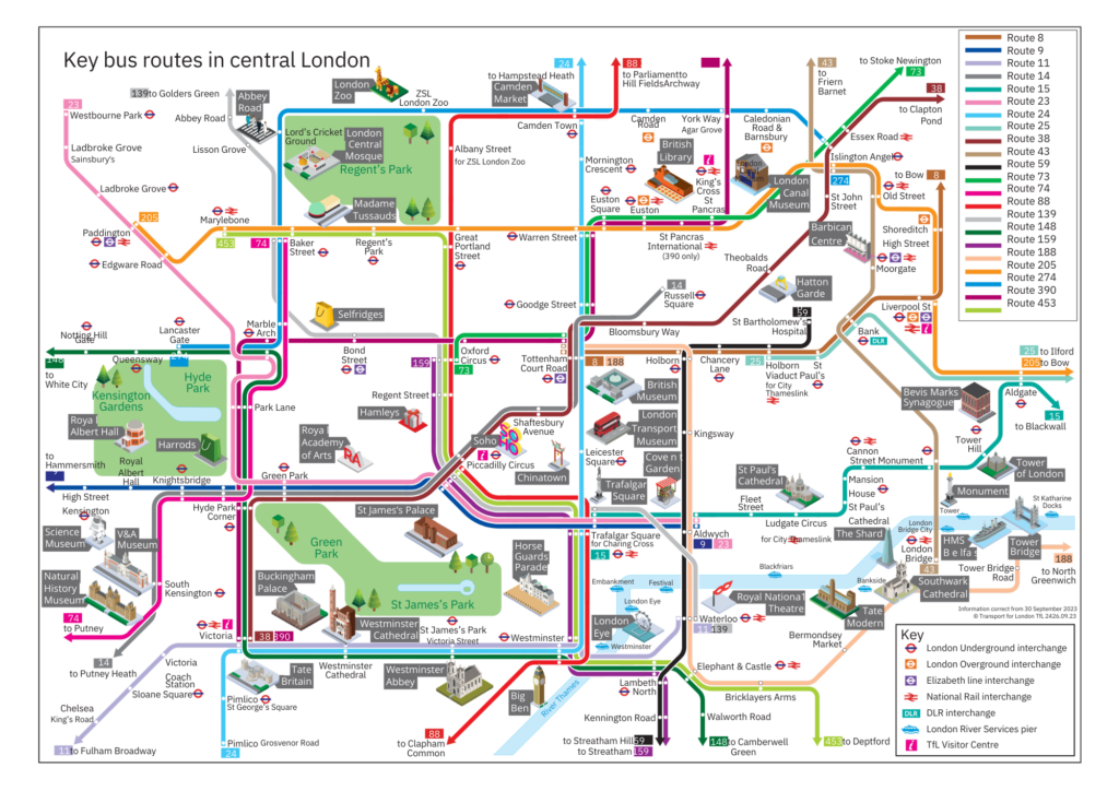
Tourist and public transport maps – bus routes
In addition to the individual spider bus maps, TfL also offer a simplified tourist bus map, with the routes colour coded (as shown).
This map also displays popular tourists attractions and interchanges with other forms of public transport such as the Underground, Overground and River Services. It is useful as an overview, to be used in consultation with the individual maps.
Night bus service
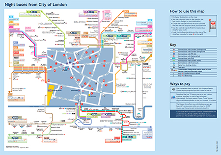
During the week when the London Underground shuts down, between midnight and 5am, a very good night bus service operates. (Additionally at weekends you can now use a night service on the London Underground – a 24/7 service runs on Friday and Saturday nights only.)
The link below to the spider bus maps will also give you night bus maps for individual boroughs – just type ‘night’ into the search field.
Visit our Practical guide to London buses page for more information.
Tourist and public transport maps – London River Commuter Service
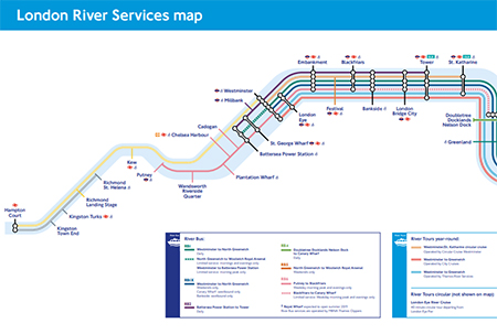
The route of the London Commuter Service is shown on the map.
Ask most Londoners about the scheduled river boat services on the River Thames and probably they will know little of what you’re talking about.
The service is there though and should be hugely attractive to visitors to London.
Visit our Scheduled river services on the River Thames page for more information.
Using Oyster and Travelcards on London’s rail networks
In the last few years the railway lines have at a slow pace become more integrated with the bus and Underground networks and now on the majority of rail lines in London you can use Oyster and Travelcards to travel as well as being valid on the buses and Underground.
Street maps
Step into any bookseller in London and there will be a wide selection of street level maps with all the sights marked clearly.
London is a very walkable city, people are often surprised just how much can be seen and how little buses and underground trains are really needed. Just pick up the one whose layout, weight and size appeals to you.
Online the most popular maps are probably Google Maps. Streetmap.co.uk is another option that is more like a paper map and may be preferred.
Stanfords travel & map shop

For anyone seriously interested in travel and maps, Stanfords is the place to go.
Their flagship store devoted to travel books and maps is in Covent Garden, between Leicester Square and Covent Garden Underground stations. If you want a map or travel book you will get the widest choice here backed up by knowledgeable and helpful staff.
Their address is 12-14 Long Acre. Long Acre is the main street that connects Leicester Square (north eastern corner) with Covent Garden.
Stanfords also have an online shop if you want product delivered to your home.
Stanfords travel & map shop website
Book discounted tours from London
Windsor Castle, Stonehenge & Bath from £91
- Choose your flexible ticket to Windsor Castle, Stonehenge & Roman Baths
- Professional guide
- Luxury air-conditioned coach with free Wi-Fi
Stonehenge & Bath from £87
- Option 1: Stonehenge & Bath (without Roman Baths entrance)
- Option 2: Stonehenge & Bath (with Roman Baths entrance)
- Stonehenge & Bath (with Jane Austen Centre entrance)
Stonehenge half-day tour from £64
- Head straight to Stonehenge for an extended visit
- Admission to Stonehenge and Stonehenge Visitor Exhibition Centre
- Executive air-conditioned coach with free Wi-Fi
- London in Your Pocket app access
Exclusive prices including admission to attractions. Air-conditioned tour coaches with free Wi-Fi
Visit our Coach tours from London page for more information.