What to do in Windsor and Windsor Castle
What to do in Windsor and Eton, getting to Windsor, restaurants and hotels
Windsor is easily accessible from London and is an ideal day trip. There is much more than just Windsor Castle, you could easily spend two or three days here.
Eton is on the other side of the River Thames from Windsor and historic Runnymede is little more than a mile away and there is a vast network of paths in Windsor Great Park to be explored.
Once royal hunting grounds, Windsor Great Park is now home of Polo matches, formal gardens and Virginia Water, a local beauty spot.
There is also a theme park - Legoland - and a horse race track with evening meetings in the summer.
Windsor Castle Things to do in Windsor Getting to Windsor Windsor hop-on hop-off sightseeing bus Hotels Restaurants
Windsor Castle
Of course the main attraction for first time visitors is Windsor Castle and is the 'must see'. Most people will take around two hours to explore Windsor Castle, so there is lots of time to explore the delights of the Windsor area.
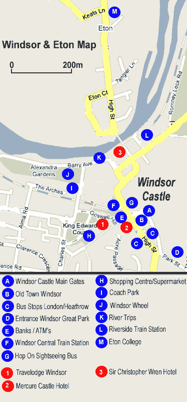
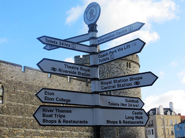
Windsor Castle is in the heart of Windsor, (the town grew up around the castle).
There are two rail stations within five minutes' walk, each of which has several services an hour to London.
Things to see and do in Windsor & Eton
Windsor is much more than just the castle; there are a wealth of things to see and do which will keep many visitors occupied for a couple of days.
The nice thing about Windsor is that most things are either in the town or in very close proximity. Like most town with significant tourist numbers there is a hop on, hop off open top sightseeing bus as well.
In the evening there is a wide choice of restaurants to suit every taste and budget, a theatre performs every evening except Sunday, and Windsor race course has regular race meeting during summer evenings.
Some ideas are:
Eton College has educated 18 former British Prime Ministers including the Duke of Wellington, Walpole, Pitt the Elder, MacMillan and Douglas-Holme. The School Dress still consists of a black tailcoat and waistcoat, and pinstriped trousers which dates from the 1850s.
Tours of the College are a fascinating experience, which includes the Cloisters, the Chapel, the oldest classroom in the College and the Museum of Eton Life.
Windsor riverfront is a good place to relax. Alexander Gardens, a traditional Victorian park borders much of the River Thames at Windsor. The Thames path can be followed all the way back to London or even Oxford. Feeding the swans, boat trips, rowing boats are just some of the evergreen activities you will find here.
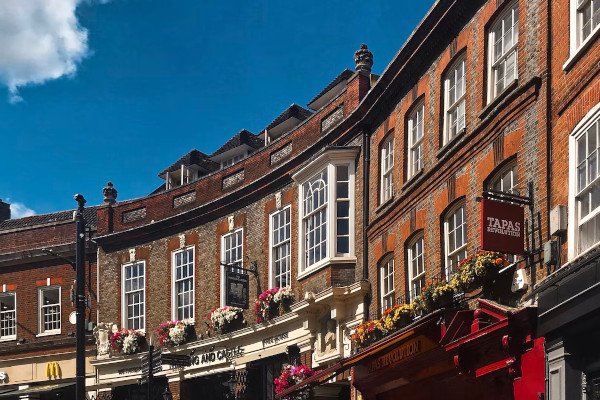
Windsor Old Town is right next to the main Windsor Castle entrance. Tourist shops have grown up around the heritage of the area; if you are minded to it is easy to pick up some souvenirs, often with a royal theme. Beyond this there is plenty to enjoy from the buildings themselves, dating from the medieval era onwards; plenty of photographic opportunities.
Windsor also has its own working theatre, a traditional historic venue opposite the castle where plays are often run that then transfer to the West End in London.
Runnymede, just three miles south-east of Windsor, on the banks of the River Thames, is the famous meadow of Runnymede. It was here in 1215 that King John sealed the Magna Carta. This charter established the principle of the constitutional monarchy and affirmed the individual's right to justice and liberty.
The American constitution is based on the Magna Carta and to commemorate this the American Bar Association erected a memorial in 1957. This can be seen on the hillside overlooking the water meadows.
Legoland Windsor has over 50 interactive rides, live shows, building workshops, driving schools and attractions and is set in 150 acres of beautiful parkland, Legoland Windsor is a different sort of family theme park. Shuttle buses run out to the park very frequently from Windsor.
Windsor Great Park offers some great walks, with the perennial attraction of the Red Deer in their enclosure. A diverse area including the Guards Polo Club which hosts polo every weekend in the summer, as well as stunning parks such as Virginia Water, a tranquil spot in every season.
How to get to Windsor
Windsor is just 20 miles west of Central London and very simple to reach by public transport.
Most visitors will take one of the two train options, but there are alternatives including a bus service that may be more convenient for some hotel districts in London.
If you are staying at nearby Heathrow there is a frequent local bus between Heathrow and Windsor.
See full Windsor transport details
The most painless way of visiting Windsor from London is on a day tour. For many visitors the most popular is the Windsor, Stonehenge and Bath tour that visits all three world class attractions in one day by comfortable air-conditioned coach.
Full details of the different kinds of tours available from London are on our Windsor tours from London page.
Windsor hop-on, hop-off sightseeing bus

Golden Tours Windsor and Thames Boat Tour
A delightful way of seeing Windsor is to take a 24-hr hop-on bus tour. This tour with Golden tours will ensure that you see all of the must-see sites around the royal town.
The audio-guide onboard will tell you all of the famous facts and hidden secrets about Windsor, enhancing your visit to this historical English town.
There are ten stops in all which you can hop on and off as many times as you like.
Plus, there are also options to add on a 24-hr river cruise and/or entry to Windsor Castle.
Thames River Cruise
Enjoy a delightful 40-minute cruise along the majestic River Thames, taking in wonderful and uninterrupted views of the historic Windsor Castle. Along the way, you’ll also see Eton College, which was attended by both Prince William and Harry, Mill House, Windsor Racecourse and the Brocas Meadows.

WINDSOR 24-HR HOP-ON BUS + RIVER CRUISE + WINDSOR CASTLE TICKETS
24-hr Hop-on hop-off sightseeing bus of Windsor
With options to add on a Thames River Cruise &/or Windsor Castle
• 24-hour hop-on hop-off bus tour ticket to explore Windsor • See Windsor Castle, Eton college and Holy Trinity Church • Audioguide & free Wi-Fi on board • Add a River Cruise and entry to Windsor Castle
Windsor hotel accommodation
There is a choice of hotel accommodation right in the town centre and there is a great choice also around neighbouring Heathrow Airport.
Heathrow has direct public transport links with Windsor and the proximity means that taxi transfers are not too expensive either.
Restaurants & food
Windsor has the full range of food options from cream teas in grand historic buildings to fast food. Opposite the castle down the hill is Starbucks, Pizza Hut, Pizza Express, Burger King and McDonald’s all in a row. Further down the hill by the theatre are more 'quality' options covering many cuisines.
At Central Station there is a large covered area with continental style cafes and coffee shops, a magnet for the Castle visitors to take a small break.
Down by the riverfront is everything from ice cream stalls to Fish & Chips to Sir Christopher Wren's Hotel where you can take a cream tea or something more substantial on the hotel's river terrace.
Over the other side of the river bridge is Eton. Eton is lined with restaurants and pubs serving food for all budgets and tastes. Windsor itself is a very affluent part of England, restaurants and shops in the town centre tend to be upmarket, but many of the useful chain stores found in most towns are there.
MOST POPULAR TOURS FROM LONDON 2024
VISITING STONEHENGE AND/OR WINDSOR AND/OR BATH
| Stonehenge Morning Half Day Tour - from £65 |
| Windsor Castle Windsor Morning & Afternoon Tours - from £70 |
| Windsor, Bath & Stonehenge (inc Lunch, no adm Roman Baths) - from £99 |
| Windsor, Bath & Stonehenge (no Lunch, inc adm Roman Baths) - from £92 |
| Windsor, Stonehenge & Salisbury - from £85 |
| Windsor & Bath Day Tour - from £85 |
| Windsor, Bath & Stonehenge (Small Group - Max 16 people) - from £156.60 |
| Stonehenge & Bath (Stonehenge admission only) - 3.5 hrs in Bath - from £88 |
| Stonehenge & Bath (Stonehenge & Baths adm) - 3.5 hrs in Bath - from £116 |
| Stonehenge & Bath (Stonehenge & Jane Austen Centre) - 3.5 hrs in Bath - from £118 |
| Stonehenge & Windsor (featuring extended time at Windsor) - from £85 |
| Stonehenge & Avebury - from £114 |
| Windsor, Stonehenge & Oxford - from £79 |
| Stratford, Cotswolds, Bath & Stonehenge - from £128 |
| Stonehenge, Glastonbury & Avebury (Small Group) - from £156.60 |
| Bath, Cotswolds, Stonehenge & Avebury (Small Group) - from £156.60 |
VISITING COTSWOLDS AND/OR OXFORD AND/OR STRATFORD AND/OR WARWICK
| Oxford, Stratford & Warwick Castle - from £74 |
| Oxford, Cotswolds & County pub lunch (Small Group) - from £156.60 |
| Stratford & Cotswolds (inc Anne Hathaway’s) - from £85 |
| Full-day Cotswolds only Tour (Small Group) - from £127 |
| In-depth Cotswolds Only Tour + Lunch - from £127 |
| Blenheim Palace, Downton Abbey Village & Cotswolds Tour - from £72 |
| Stratford, Cotswolds, Bath & Stonehenge - from £128 |
| Windsor, Stonehenge & Oxford - from £79 |
| Oxford & Cambridge Tour (May-Sep only) - from £97 |
| Downton Abbey & Blenheim Palace (Small Group) - £156.60 |
VISITING CANTERBURY, LEEDS CASTLE & DOVER
| Small group Leeds Castle, Dover & Canterbury with river cruise - from £149 |
| Dover Castle, White Cliffs & Canterbury - from £125 |
| Canterbury, Dover & Kent Villages - £139 |
SPECIAL THEME TOURS
| Stonehenge Special Access (Walk Among Stones) Tours |
| Downton Abbey + Highclere Castle Tours |
| Harry Potter Tours |
| London Rock Tour |
DAY TOURS BY TRAIN TO LIVERPOOL, PARIS & SCOTLAND
| Beatles Liverpool Day Tour - £198 |
| Day Trip to Paris - from £259 |
| Day Trip to Edinburgh - from £225 |
2 TO 12 DAY TOURS COVERING GREAT BRITAIN, IRELAND, PARIS & AMSTERDAM
| 2-day Windsor, Stonehenge, Bath & Oxford - from £349 |
| 3-day Stonehenge, Glastonbury, Bath & SW - from £275 |
| 5-day Peak District, Wales & Yorkshire- from £425 |
| 2-day private Stonehenge, Bath, Cotswolds & Oxford - from £650 |
| Budget 3 days in Paris - from £289 (not currently available) |
| Luxury 2 & 3 days in Paris - from £399 (not currently available) |
| 2-day Edinburgh - from £312 |
| 3-day Edinburgh & Scotland Weekend - from £379 (not currently available) |
| 3-day Edinburgh & Scotland Anytime - from £999 |
| 6-12-day tours of Great Britain and Ireland - from £1425 |


