Avebury, West Kennet Long Barrow and Silbury Hill self guided walk
3-mile walk visiting three ancient monuments
Join us on a short walk around the Avebury area, taking in two other monuments, Silbury Hill and West Kennet Long Barrow.
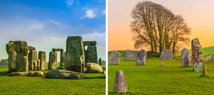
First take your time to visit the Avebury site. There is of course Avebury henge, but Avebury village is also a worthwhile place to explore.
The National Trust museums and guided walk of Avebury henge would give you good background to further enhance your walk experience.
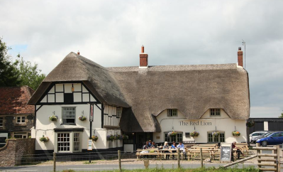
If you have come by public bus, it will have dropped you off outside the pub pictured, the Red Lion. This is our starting point.
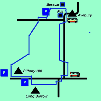
The walk is about 3 miles, nearly all on grass paths. There are no toilets or food available on the walk, other than at Avebury. We only provide the crudest of maps below, but on the ground it is very straight forward if you follow these notes.
Getting started on your Avebury walk with map
Start at the Red Lion pub
The Red Lion Avebury Pub is the only inn in the world that is located inside a prehistoric stone circle.
Claiming the dubious honour of once being "Britain's most haunted pub", the Red Lion at Avebury has a long history.
The building dates back to the 16th century, where it had its origins as a farmhouse before it became a coaching inn in the 19th century.
It is said that the sound of horses’ hooves can often be heard at night hitting the cobbles outside as a carriage arrives with a headless horseman....
An ancient well, dating back to the 1600s is a popular draw for visitors: it is said that the body of an unfortunate murdered woman lies at the bottom. The well now sits inside the pub; visitors looking to sit and have a drink can occupy a glass table with a view straight down into the murky depths!
The Well Room is named after Alexander Keiller who excavated the ancient stone circle surrounding the pub.
Continuing your walk...
From the Red Lion we are walking in between the avenue of stones that run due south, parallel to the road running to West Kennet.
Cross the road which junctions off west just south of the Red Lion towards Devizes and follow the road south going through the main south entrance of the henge.
Following the Avenue of stones...
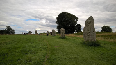
Follow the historic avenue of stones
After a few metres through the entrance there is a gate which gives you access to the avenue of stones on your right. Follow the historic avenue of stones. The stones form your pathway and will probably be one of the main memories you will have of your visit to Avebury.
When the avenue of stones ends you are by the road with a style providing exit onto the road. Now follow the road, continuing south and facing the oncoming traffic, which is slight but includes large buses.
Soon on the other side of the road there is another style into a field. Parallel the road in the field towards a farm and about 100m before the end of the road, exit the field via another style onto the road.
The Ridgeway - ancient trading route
If you wish you can make a detour following the signposted footpaths up to the top of the hill on your left. The Ridgeway, an ancient trading route follows this crest. On the crest you will find a cluster of Neolithic burial mounds and the Sanctuary. The burial mounds here are relatively small and closed up.
The Sanctuary and West Kennet Long Barrow
West Kennet, on the main walk is much more interesting. By the A4 main road on the crest is the Sanctuary. This was a small henge, thought to be where the avenue of stones started and where the people going to Avebury would congregate. There is nothing but a barren field now with markers to show you the layout of this henge.
Going back to the main walk, at the T junction with the main A4 road, turn right along this major road. This is a busy road, so take care crossing the road.
About 100m along you will see a lane branching off south, with the unusual thatched wall pictured left on the corner. Walk down the lane past some large houses.
After a few hundred metres you cross over an old stone bridge fording a narrow stream. On the other side of the bridge take the clearly signed footpath right.
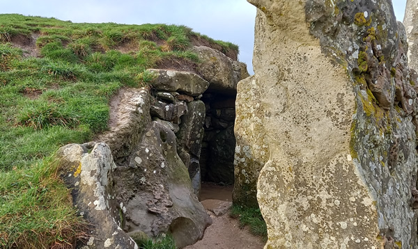
West Kennet Long Barrow
Silbury Hill starts to appear ahead. Well before you reach Silbury Hill, you will come across a well surfaced path going left up the hill to your left. At the top of the gradient is West Kennet Long Barrow, well worth the excursion.
Source of the River Kennet - Swallowhead Springs
On your return back down the hill, at the point where you rejoin the path you left to come up the hill is a tree. Hanging in the tree you may well see various items hanging.
This is a pagan place. One of the sources of the River Kennet is just up ahead of you (known as Swallowhead Springs) and the spring is a sacred pagan place. The items left in the tree are left by the pagans.
Turn left at the junction by the tree, continuing on the original path. After passing through a kissing gate the path turns sharp right and up to the main A4 road again.
Silbury Hill
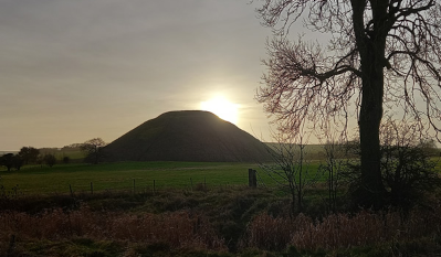
Follow the main road left using the pavement provided over to Silbury Hill. On the other side of the hill there is a car-park and viewing platform.
Just behind the viewing platform, there is a clearly marked footpath sign indicating Avebury, 1 mile. You follow the clear path through fields, getting a different perspective of Silbury Hill.
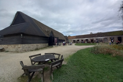
National Trust Alexander Keiller Museum
When you come to a T junction of paths, turn left. Follow the path until it exits onto the Avebury to Devizes road, almost opposite the car/coach park for Avebury.
Walk through the car park to the picnic area at the rear and follow the access path to the National Trust Alexander Keiller Museum Museum.

SMALL GROUP STONEHENGE, GLASTONBURY & AVEBURY
Stonehenge, Glastonbury & Avebury Small Group guided day tour from London
Flexi adult from £174 • Best rate adult from £156.60 • Flexi child (3-15 years) from £154 • Best rate child from £138.60
• Small group day trip - maximum 16 people per tour • Admission to Stonehenge, Glastonbury Abbey & Avebury Stone Circle • Beat the crowds at Stonehenge - go there first! • Professional guide • Photo stop at Glastonbury Tor and entry to Chalice Well Gardens
STONEHENGE & AVEBURY TOUR
Visit the largest and most famous henges in one day
Adult from £114 • Child (age 5-17) from £109
• Entrance into Stonehenge • Walking tour of Avebury & Avebury henge • Free time for lunch in Avebury • Visit West Kennet Long Barrow • Professional guide • Operates Wednesday, Friday & Sunday
MOST POPULAR TOURS FROM LONDON 2024
VISITING STONEHENGE AND/OR WINDSOR AND/OR BATH
| Stonehenge Morning Half Day Tour - from £65 |
| Windsor Castle Windsor Morning & Afternoon Tours - from £70 |
| Windsor, Bath & Stonehenge (inc Lunch, no adm Roman Baths) - from £99 |
| Windsor, Bath & Stonehenge (no Lunch, inc adm Roman Baths) - from £92 |
| Windsor, Stonehenge & Salisbury - from £85 |
| Windsor & Bath Day Tour - from £85 |
| Windsor, Bath & Stonehenge (Small Group - Max 16 people) - from £156.60 |
| Stonehenge & Bath (Stonehenge admission only) - 3.5 hrs in Bath - from £88 |
| Stonehenge & Bath (Stonehenge & Baths adm) - 3.5 hrs in Bath - from £116 |
| Stonehenge & Bath (Stonehenge & Jane Austen Centre) - 3.5 hrs in Bath - from £118 |
| Stonehenge & Windsor (featuring extended time at Windsor) - from £85 |
| Stonehenge & Avebury - from £114 |
| Windsor, Stonehenge & Oxford - from £79 |
| Stratford, Cotswolds, Bath & Stonehenge - from £128 |
| Stonehenge, Glastonbury & Avebury (Small Group) - from £156.60 |
| Bath, Cotswolds, Stonehenge & Avebury (Small Group) - from £156.60 |
VISITING COTSWOLDS AND/OR OXFORD AND/OR STRATFORD AND/OR WARWICK
| Oxford, Stratford & Warwick Castle - from £74 |
| Oxford, Cotswolds & County pub lunch (Small Group) - from £156.60 |
| Stratford & Cotswolds (inc Anne Hathaway’s) - from £85 |
| Full-day Cotswolds only Tour (Small Group) - from £127 |
| In-depth Cotswolds Only Tour + Lunch - from £127 |
| Blenheim Palace, Downton Abbey Village & Cotswolds Tour - from £72 |
| Stratford, Cotswolds, Bath & Stonehenge - from £128 |
| Windsor, Stonehenge & Oxford - from £79 |
| Oxford & Cambridge Tour (May-Sep only) - from £97 |
| Downton Abbey & Blenheim Palace (Small Group) - £156.60 |
VISITING CANTERBURY, LEEDS CASTLE & DOVER
| Small group Leeds Castle, Dover & Canterbury with river cruise - from £149 |
| Dover Castle, White Cliffs & Canterbury - from £125 |
| Canterbury, Dover & Kent Villages - £139 |
SPECIAL THEME TOURS
| Stonehenge Special Access (Walk Among Stones) Tours |
| Downton Abbey + Highclere Castle Tours |
| Harry Potter Tours |
| London Rock Tour |
DAY TOURS BY TRAIN TO LIVERPOOL, PARIS & SCOTLAND
| Beatles Liverpool Day Tour - £198 |
| Day Trip to Paris - from £259 |
| Day Trip to Edinburgh - from £225 |
2 TO 12 DAY TOURS COVERING GREAT BRITAIN, IRELAND, PARIS & AMSTERDAM
| 2-day Windsor, Stonehenge, Bath & Oxford - from £349 |
| 3-day Stonehenge, Glastonbury, Bath & SW - from £275 |
| 5-day Peak District, Wales & Yorkshire- from £425 |
| 2-day private Stonehenge, Bath, Cotswolds & Oxford - from £650 |
| Budget 3 days in Paris - from £289 (not currently available) |
| Luxury 2 & 3 days in Paris - from £399 (not currently available) |
| 2-day Edinburgh - from £312 |
| 3-day Edinburgh & Scotland Weekend - from £379 (not currently available) |
| 3-day Edinburgh & Scotland Anytime - from £999 |
| 6-12-day tours of Great Britain and Ireland - from £1425 |


